
Zoom Earth

Category:Weather Developer:Neave Interactive
Size:28.5 MBRate:4.6
OS:Android 8.0+Updated:May 03,2025

 Download
  Application Description
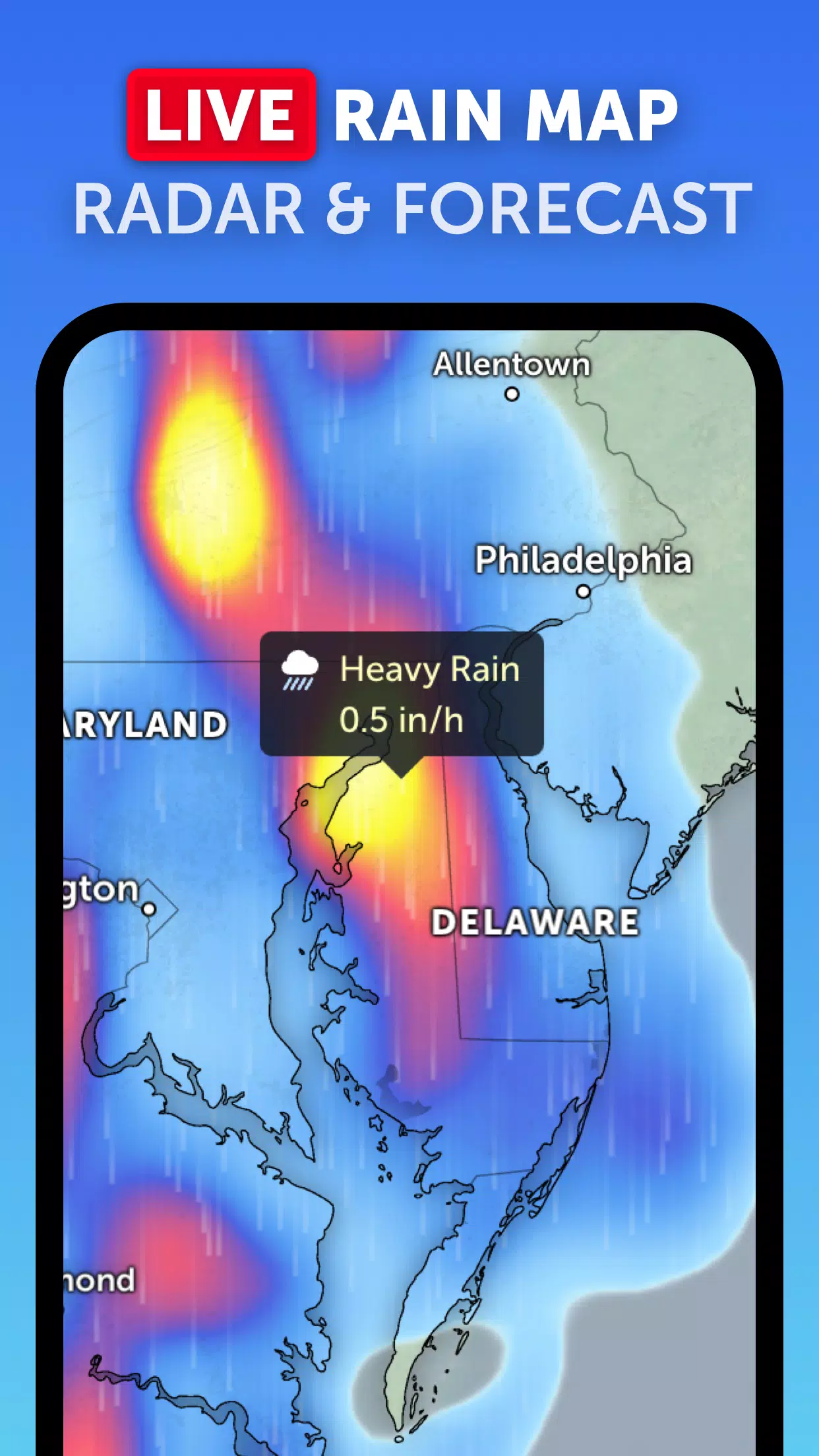
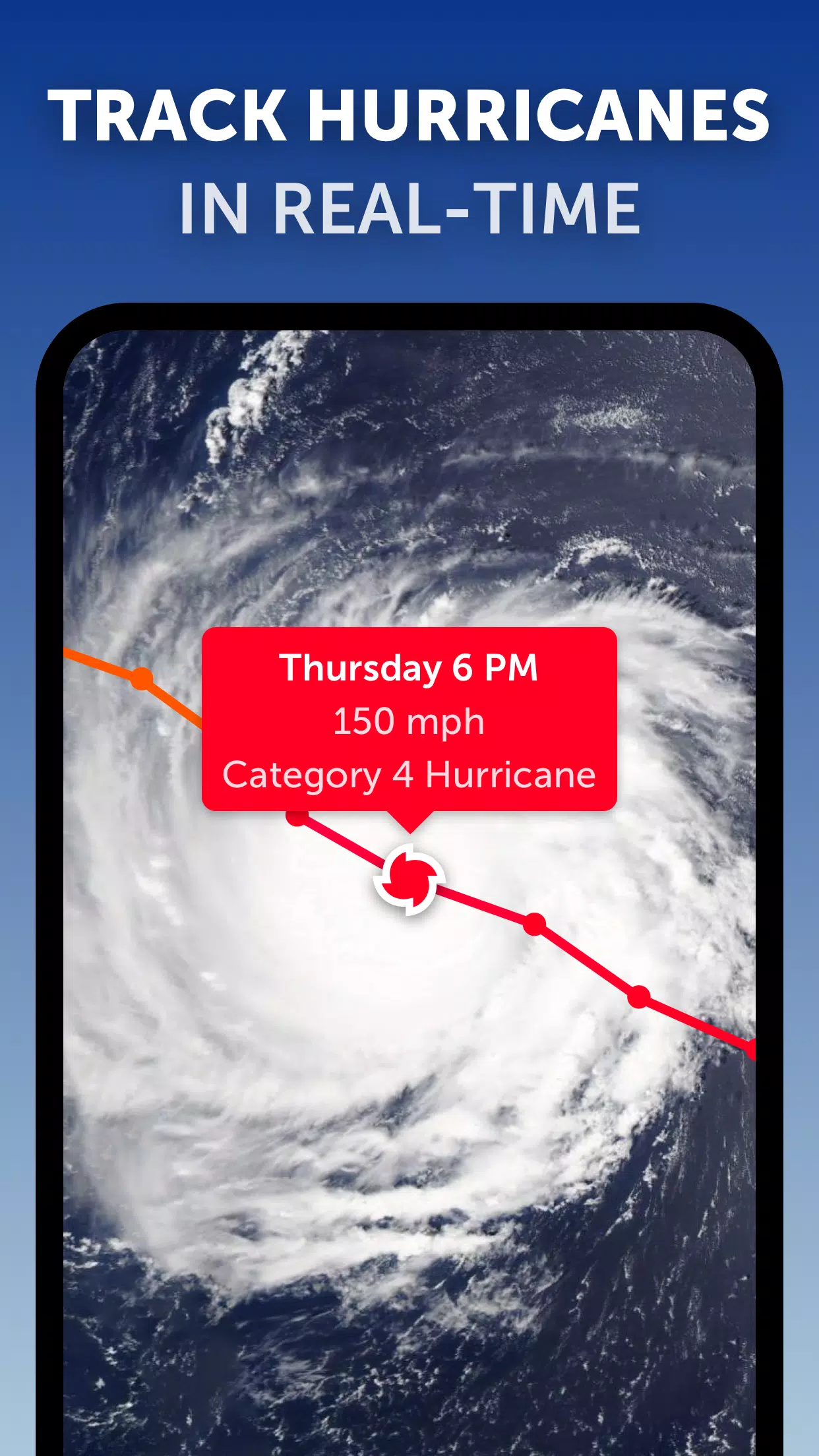
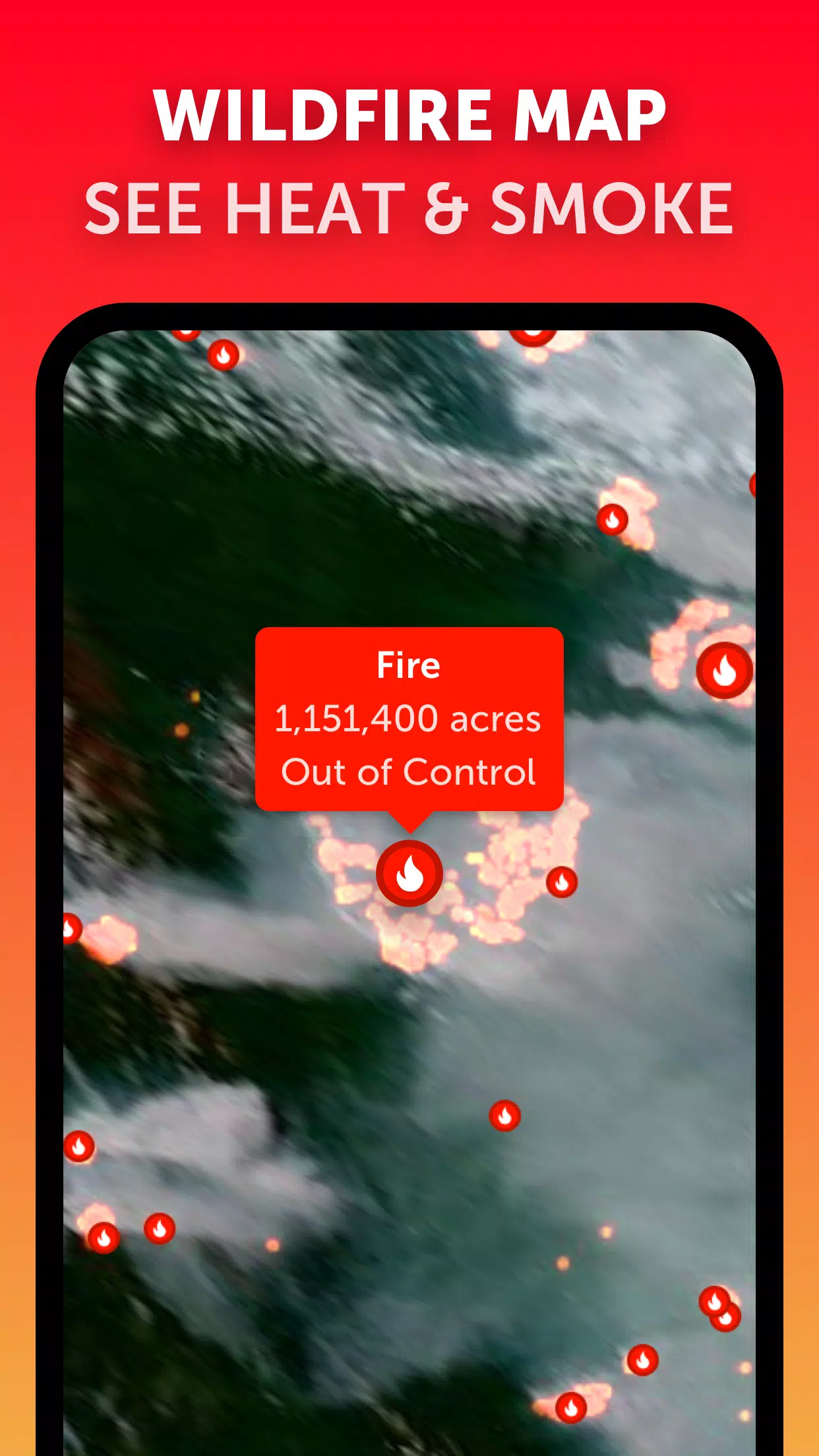
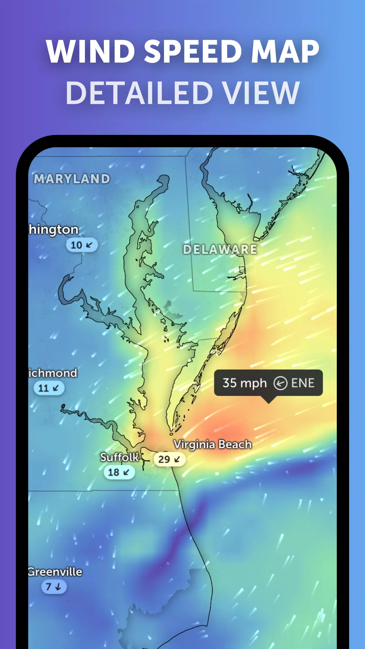
Zoom Earth is your go-to interactive weather map and real-time hurricane tracker, designed to keep you informed about the world's weather patterns. It offers a comprehensive suite of features including satellite imagery, rain radar, weather forecast maps, hurricane tracking, wildfire tracking, and a host of customization options to tailor your experience.
Key Features
Satellite Imagery: Zoom Earth provides weather maps with near real-time satellite imagery sourced from NOAA GOES, JMA Himawari, EUMETSAT Meteosat, and NASA's polar-orbiting satellites Aqua and Terra, ensuring you have the latest visual data at your fingertips.
Rain Radar: Stay one step ahead of the weather with our weather radar map, which displays real-time rain and snow data detected by ground-based Doppler radar, helping you anticipate and prepare for incoming storms.
Weather Forecast Maps: Dive into our visually stunning and interactive global forecast maps. These maps cover a wide range of weather metrics including precipitation, wind speed and gusts, temperature, "feels like" temperature, relative humidity, dew point, and atmospheric pressure forecasts, offering a comprehensive view of upcoming weather conditions.
Hurricane Tracking: Keep a close watch on hurricanes from their inception to Category 5 status with our top-tier tropical tracking system. We utilize the most current data from the National Hurricane Center (NHC), Joint Typhoon Warning Center (JTWC), Naval Research Laboratory (NRL), and the International Best Track Archive for Climate Stewardship (IBTrACS) to ensure accuracy and timeliness.
Wildfire Tracking: Stay informed about wildfires with our active fires and heat spots overlay. This feature uses daily updates from NASA's Fire Information for Resource Management System (FIRMS) to show points of very high temperature detected by satellite, helping you monitor fire outbreaks effectively.
Customization: Make Zoom Earth your own with extensive customization options. Adjust temperature units, wind units, time zones, animation styles, and more to suit your preferences and needs.
What's New in Version 3.1
Last updated on Sep 19, 2024
- Enhanced user experience with reduced clutter when viewing multiple tropical systems.
- Improved alert systems with separate notifications for Atlantic and Eastern Pacific systems.
- Refined map labels for clearer and more intuitive navigation.
Screenshot
 Reviews
Post Comments+
Latest Apps
MORE+
Reviews
Post Comments+
Latest Apps
MORE+
-
 Influence ID
Communication 丨 34.40M
 Download
-
 Neterra.TV (Mobile and Tablet)
Personalization 丨 14.90M
Download
-
 AGN INJECTOR (SSH/DNS/SSL) VPN
Tools 丨 95.60M
Download
-
 GraceChat
Communication 丨 146.20M
Download
-
 Neudesic Pulse
Communication 丨 20.20M
Download
-
 Qantas Entertainment
Video Players & Editors 丨 66.70M
Download
Similar recommendations
MORE+
Top News
MORE+

-

-
 Shovel Knight Digs In, Promises More
Jun 25,2024
-

-
 Elden Ring Fan Shows Off Mohg Cosplay
Jan 22,2022
Topics
MORE+
- Your Guide to the Best News & Magazine Subscriptions
- Top Free Puzzle Games on Google Play
- Top Sports News and Score Apps
- Stylized Realistic Art Style Games for Android
- Fun Word Games to Play with Friends
- Top Action Games of 2024
- Must-Have Business Productivity Apps
- Relaxing Casual Games to Unwind With
Trending apps
MORE+
-
1

m.a.i.n59.72M
Introducing m.a.i.n, the revolutionary app that is changing the way we connect and share information. With m.a.i.n, you no longer need to carry around physical business cards or worry about sharing your contact details with strangers. Simply create a m.a.i.n Name and all your contact information and
-
2

Photos Recovery-Restore Images15.00M
PhotoRecovery: Restore Pics is a user-friendly Android app for effortlessly recovering deleted photos from internal and external storage without rooting. Its intuitive interface and robust features scan for and restore major image formats, letting you preview and selectively recover photos. An int
-
3

Yeahub-live video chat79.00M
YeaHub: Your Gateway to Seamless Video ChatStay connected with friends and loved ones, anytime, anywhere with YeaHub, the ultimate live video chat app. Experience crystal-clear video calls that bridge the distance, making communication more than just words. With YeaHub, you can engage in face-to-fac
-
4

Advanced Download Manager56.13M
Advanced Download Manager: Your Ultimate Download CompanionAdvanced Download Manager is the ultimate solution for anyone facing unreliable or slow internet connections. This powerful app acts as your indispensable download companion, ensuring seamless and uninterrupted downloads. Whether you're inte
-
5

YUMS57.16M
YUMS is the ultimate app designed to revolutionize your university experience. It combines convenience, organization, and timeliness to streamline every aspect of your academic life. Forget about the hassle of keeping track of class schedules and attendance manually. With YUMS, you can easily access
-
6

Blued TW151.19 MB
Requirements (Latest version)Android 6.0 or higher is required.
90.11 MB
Download74.5 MB
Download58.4 MB
Download81.8 MB
Download40.3 MB
Download13.9 MB
Download