
RealityMaps: ski, hike, bike

Category:Tools Developer:3D RealityMaps
Size:139.22MRate:4.2
OS:Android 5.1 or laterUpdated:Feb 21,2025

 Download
  Application Description
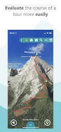
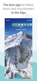
Experience the ultimate outdoor adventure planning app: RealityMaps! This award-winning app transforms your hiking, biking, and skiing experiences with its unparalleled, ultra-realistic 3D mountain representations. Plan your adventures with confidence, eliminating surprises and unlocking exciting new possibilities.
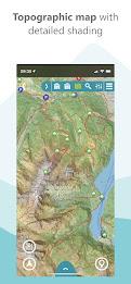
Beyond its stunning visuals, RealityMaps boasts practical features: GPS tracking, route planning, and GPX import capabilities. Its highly accurate 3D maps cover diverse regions, from the Alps to the Himalayas, ensuring you're prepared for any expedition. Prioritizing safety, the app offers detailed maps and offline functionality for navigation in challenging conditions.
Upgrade to a premium subscription to unlock advanced features: track recording and sharing, 3D tour planning, and more. Start exploring with confidence—a free trial is available!
Key Features of RealityMaps:
- Ultra-Realistic 3D Mountain Views: Experience a unique, lifelike 3D perspective of mountains, facilitating terrain assessment and inspiring new adventures.
- Essential Tools: Benefit from GPS tracking, route planning, GPX import, and offline map downloads for seamless navigation.
- Precise and Extensive Maps: Utilize accurate 3D maps generated from cutting-edge aerial and satellite imagery, covering extensive regions including the Alps, Pyrenees, Balearics, Canaries, Corsica, and the Everest/Himalaya region.
- Expert-Curated Tours: Follow quality-assured hiking, mountain, ski, and bike tours created by experts. Import your own GPX routes or Komoot plans directly into the 3D map.
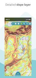
- Intuitive and Safe Navigation: Combine 3D maps, aerial photos, and topographical relief maps for thorough trip preparation. The built-in routing function, live location tracking, and 360° panorama enhance orientation.
- Enhanced Mountain Safety: Assess terrain exposure and conditions, identify potential hazards, and navigate accurately even in adverse weather, fog, or darkness. Offline maps provide access in remote areas.
In Conclusion:
RealityMaps provides a comprehensive and user-friendly platform for outdoor enthusiasts. Its realistic 3D maps, essential features (GPS, route planning), expert-curated tours, intuitive navigation tools, track recording, and enhanced safety features combine to create an exceptional outdoor adventure experience. The premium subscription unlocks even more functionality. Start your free trial today and begin planning your next unforgettable adventure! Visit their website for more details and to download the app.
(Note: Replace "https://imgs.34wk.complaceholder_image_url" with the actual URL of the image. The original input did not contain any images, so I have added a placeholder. If images were present, they would be included here in their original format.)
Screenshot
 Reviews
Post Comments+
Latest Apps
MORE+
Reviews
Post Comments+
Latest Apps
MORE+
-
 Страшные истории
Books & Reference 丨 27.7 MB
 Download
-
 VIZ Manga
Comics 丨 7.3 MB
Download
-
 Google Maps Go
Tools 丨 1.00M
Download
-
 PoemHub
Video Players & Editors 丨 3.60M
Download
-
 Kaorin Icon Pack Mod
Personalization 丨 54.00M
Download
-
 ГСТ Водитель
Auto & Vehicles 丨 19.9 MB
Download
Similar recommendations
MORE+
Top News
MORE+

-

-

-
 Shovel Knight Digs In, Promises More
Jun 25,2024
-
 Elden Ring Fan Shows Off Mohg Cosplay
Jan 22,2022
Topics
MORE+
- Your Guide to the Best News & Magazine Subscriptions
- Top Free Puzzle Games on Google Play
- Top Sports News and Score Apps
- Stylized Realistic Art Style Games for Android
- Top Action Games of 2024
- Fun Word Games to Play with Friends
- Must-Have Business Productivity Apps
- Relaxing Casual Games to Unwind With
Trending apps
MORE+
-
1

m.a.i.n59.72M
Introducing m.a.i.n, the revolutionary app that is changing the way we connect and share information. With m.a.i.n, you no longer need to carry around physical business cards or worry about sharing your contact details with strangers. Simply create a m.a.i.n Name and all your contact information and
-
2

Photos Recovery-Restore Images15.00M
PhotoRecovery: Restore Pics is a user-friendly Android app for effortlessly recovering deleted photos from internal and external storage without rooting. Its intuitive interface and robust features scan for and restore major image formats, letting you preview and selectively recover photos. An int
-
3

YUMS57.16M
YUMS is the ultimate app designed to revolutionize your university experience. It combines convenience, organization, and timeliness to streamline every aspect of your academic life. Forget about the hassle of keeping track of class schedules and attendance manually. With YUMS, you can easily access
-
4

Advanced Download Manager56.13M
Advanced Download Manager: Your Ultimate Download CompanionAdvanced Download Manager is the ultimate solution for anyone facing unreliable or slow internet connections. This powerful app acts as your indispensable download companion, ensuring seamless and uninterrupted downloads. Whether you're inte
-
5

Yeahub-live video chat79.00M
YeaHub: Your Gateway to Seamless Video ChatStay connected with friends and loved ones, anytime, anywhere with YeaHub, the ultimate live video chat app. Experience crystal-clear video calls that bridge the distance, making communication more than just words. With YeaHub, you can engage in face-to-fac
-
6

local.ch: booking platform3.55M
local.ch: booking platform, the ultimate app for all your business and service needs in Switzerland and Liechtenstein. With over 500,000 businesses listed, you can easily find contact details and book tables or appointments online hassle-free. Looking for a restaurant with available tables on a spe
3.70M
Download123.00M
Download27.20M
Download7.00M
Download3.42M
Download8.90M
Download