
MAPinr - KML/KMZ/OFFLINE/GIS

Category:Travel & Local Developer:Xylem Technologies
Size:76.3 MBRate:5.0
OS:Android 6.0+Updated:May 05,2025

 Download
  Application Description
Thank you for choosing Mapinr. In an era where Android version updates come at a rapid pace, sustaining non-profit projects like ours becomes challenging. Yet, we remain committed to our mission of providing a secure, privacy-friendly, and affordable app for all users.
We understand that the minimum Android version required by Google Play may not be supported by all devices. To address this, we offer downloads for older Android versions (below Android 14), which are no longer available on the Play Store, directly from our website.
Are you interested in managing your own points of interest or placing your photos on a map? MAPinr is the perfect, ad-free Android app for you. It enables you to manage your kml/kmz files and view your gpx files on various maps, making it ideal for professionals as well as enthusiasts of hiking, cycling, running, skiing, and more.
We value your feedback and suggestions on how to enhance MAPinr. Please share your thoughts with us at [email protected]. We appreciate constructive criticism and understand that software bugs can be frustrating. Please remain patient as our resources are limited, and we may not be able to implement all suggestions immediately.
MAPinr offers the following features:
Ad-Free Experience: Enjoy using the app without any interruptions from advertisements.
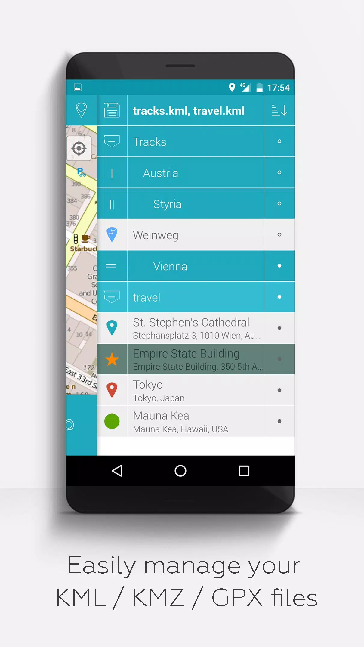
Organized File Management: Utilize a hierarchical folder structure to manage multiple kml/kmz/gpx files efficiently.
Comprehensive KML/KMZ Handling: Create, load, edit, save, import, export, and share kml/kmz files seamlessly.
Versatile Waypoint, Line/Track, and Polygon Management: Create, edit, save, import, export, and share these elements with ease.
Photomaps Creation: Add pictures to your waypoints to create personalized photomaps.
Multi-Map Display: View waypoints, lines/tracks, and polygons on various maps including Maps, Satellite, Hybrid, OpenStreetMap, Opentopomap, and Opencyclemap.
Coordinate Sharing: Easily share the coordinates of your waypoints with others.
Customizable Visuals: Individually colorize waypoints, lines/tracks, and polygons to suit your preferences.
Interoperability: Open exported kml/kmz files in other apps for further use.
Advanced Search Capabilities: Search by name, address, and coordinates to find what you need quickly.
Location Sharing: Share your location with friends to keep them updated on your whereabouts.
Simultaneous File Viewing: Display multiple kml/kmz/gpx files at the same time for comprehensive analysis.
File Merging: Merge kml/kmz files to streamline your data management.
Cloud Integration: Integrate with cloud services for easy access and backup.
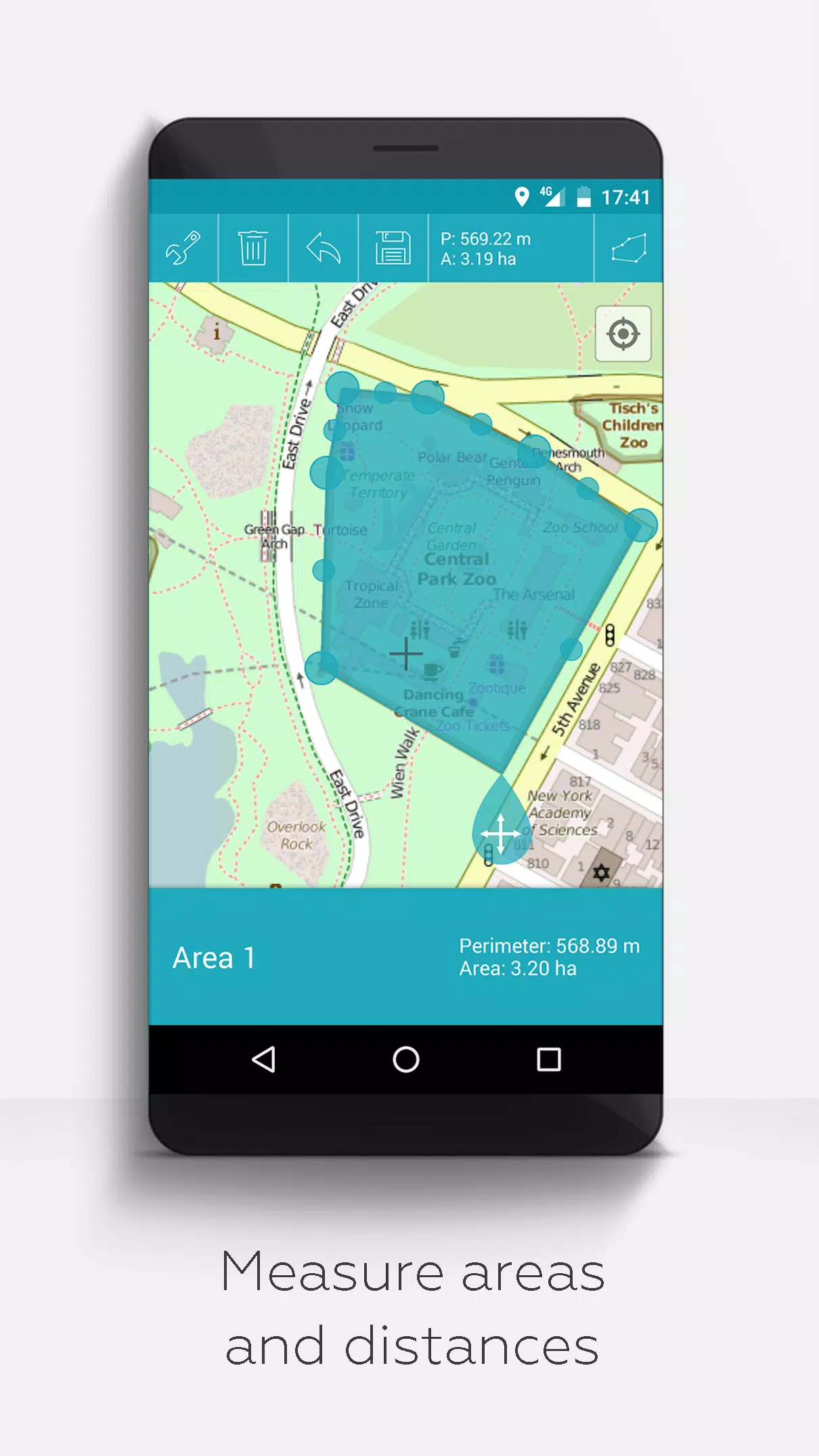
Measurement Tools: Measure distances and areas directly on your map for accurate planning.
Multilingual Support: Currently available in English, Spanish, Lithuanian, and Polish.
Extended Features (Available for free with donations or a LinkedIn like; activate in Settings):
Offline Maps: Download maps for free using OpenStreetMap to use offline.
GPX Viewer: View your GPX files without any hassle.
Web Map Service (WMS) Support: Display additional map data from services like www.data.gov using WMS.
Custom Metadata Creation: Create metadata tailored to your specific needs.
Custom Icons: Upload and use your own icons to personalize your maps.
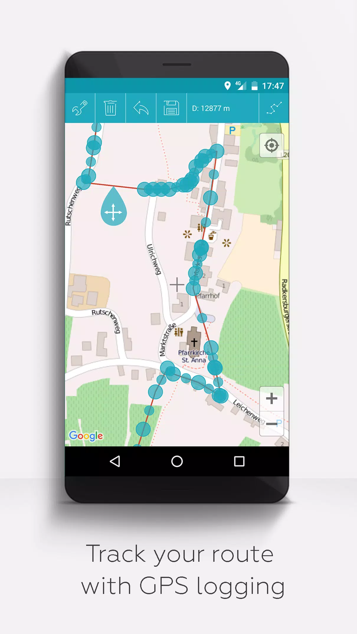
GPS Track Recording: Record your GPS tracks for later reference and analysis.
Unlike other apps, MAPinr respects your privacy and does not collect or sell your data. Donations are a voluntary way to support our non-profit efforts.
Screenshot
 Reviews
Post Comments+
Latest Apps
MORE+
Reviews
Post Comments+
Latest Apps
MORE+
-
 CricScore Line Guru Pro - Live
Personalization 丨 34.30M
 Download
-
 Vip Betting Tips
Personalization 丨 17.20M
Download
-
 Mobby
Mobby
Personalization 丨 50.50M
Download
-
 WEATHER NOW Mod
Lifestyle 丨 58.30M
Download
-
 Speak - Language Learning
Lifestyle 丨 195.80M
Download
-
 Pixly – Icon Pack Mod
Lifestyle 丨 121.70M
Download
Similar recommendations
MORE+
Top News
MORE+

-

-
 Shovel Knight Digs In, Promises More
Jun 25,2024
-

-
 Elden Ring Fan Shows Off Mohg Cosplay
Jan 22,2022
Topics
MORE+
- Your Guide to the Best News & Magazine Subscriptions
- Top Free Puzzle Games on Google Play
- Top Sports News and Score Apps
- Stylized Realistic Art Style Games for Android
- Fun Word Games to Play with Friends
- Top Action Games of 2024
- Must-Have Business Productivity Apps
- Relaxing Casual Games to Unwind With
Trending apps
MORE+
-
1

m.a.i.n59.72M
Introducing m.a.i.n, the revolutionary app that is changing the way we connect and share information. With m.a.i.n, you no longer need to carry around physical business cards or worry about sharing your contact details with strangers. Simply create a m.a.i.n Name and all your contact information and
-
2

Photos Recovery-Restore Images15.00M
PhotoRecovery: Restore Pics is a user-friendly Android app for effortlessly recovering deleted photos from internal and external storage without rooting. Its intuitive interface and robust features scan for and restore major image formats, letting you preview and selectively recover photos. An int
-
3

Blued TW151.19 MB
Requirements (Latest version)Android 6.0 or higher is required.
-
4

Yeahub-live video chat79.00M
YeaHub: Your Gateway to Seamless Video ChatStay connected with friends and loved ones, anytime, anywhere with YeaHub, the ultimate live video chat app. Experience crystal-clear video calls that bridge the distance, making communication more than just words. With YeaHub, you can engage in face-to-fac
-
5

Advanced Download Manager56.13M
Advanced Download Manager: Your Ultimate Download CompanionAdvanced Download Manager is the ultimate solution for anyone facing unreliable or slow internet connections. This powerful app acts as your indispensable download companion, ensuring seamless and uninterrupted downloads. Whether you're inte
-
6

local.ch: booking platform3.55M
local.ch: booking platform, the ultimate app for all your business and service needs in Switzerland and Liechtenstein. With over 500,000 businesses listed, you can easily find contact details and book tables or appointments online hassle-free. Looking for a restaurant with available tables on a spe
3.55M
Download36.00M
Download10.31M
Download27.19M
Download64.30M
Download57.00M
Download