
スーパー地形 - GPS対応地形図アプリ
Category:Maps & Navigation Developer:kashmir3d
Size:16.7 MBRate:3.3
OS:Android 5.0+Updated:May 11,2025

 Download
  Application Description
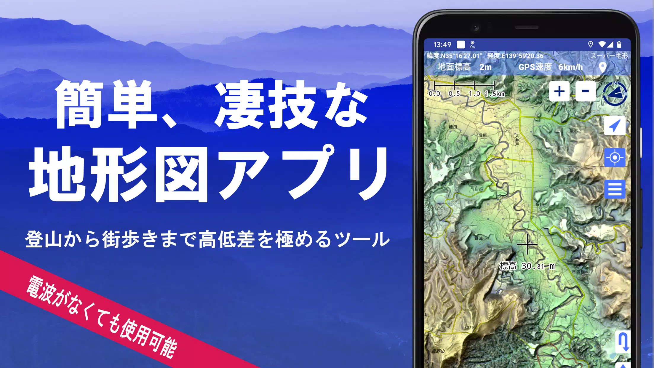
Discover the power of over 100 types of maps at your fingertips, from the detailed Geographical Survey Institute map to specialized maps for mountain climbing and urban exploration. With Super Terrain, you can leverage the height differences to enhance your outdoor adventures, whether you're scaling peaks or strolling through city streets.
Super Terrain was honored with the 2018 Japan Cartographic Society Award for Best Work, a testament to its excellence in mapping technology.
- Utilize "super terrain data" that highlights terrain with our unique technology.
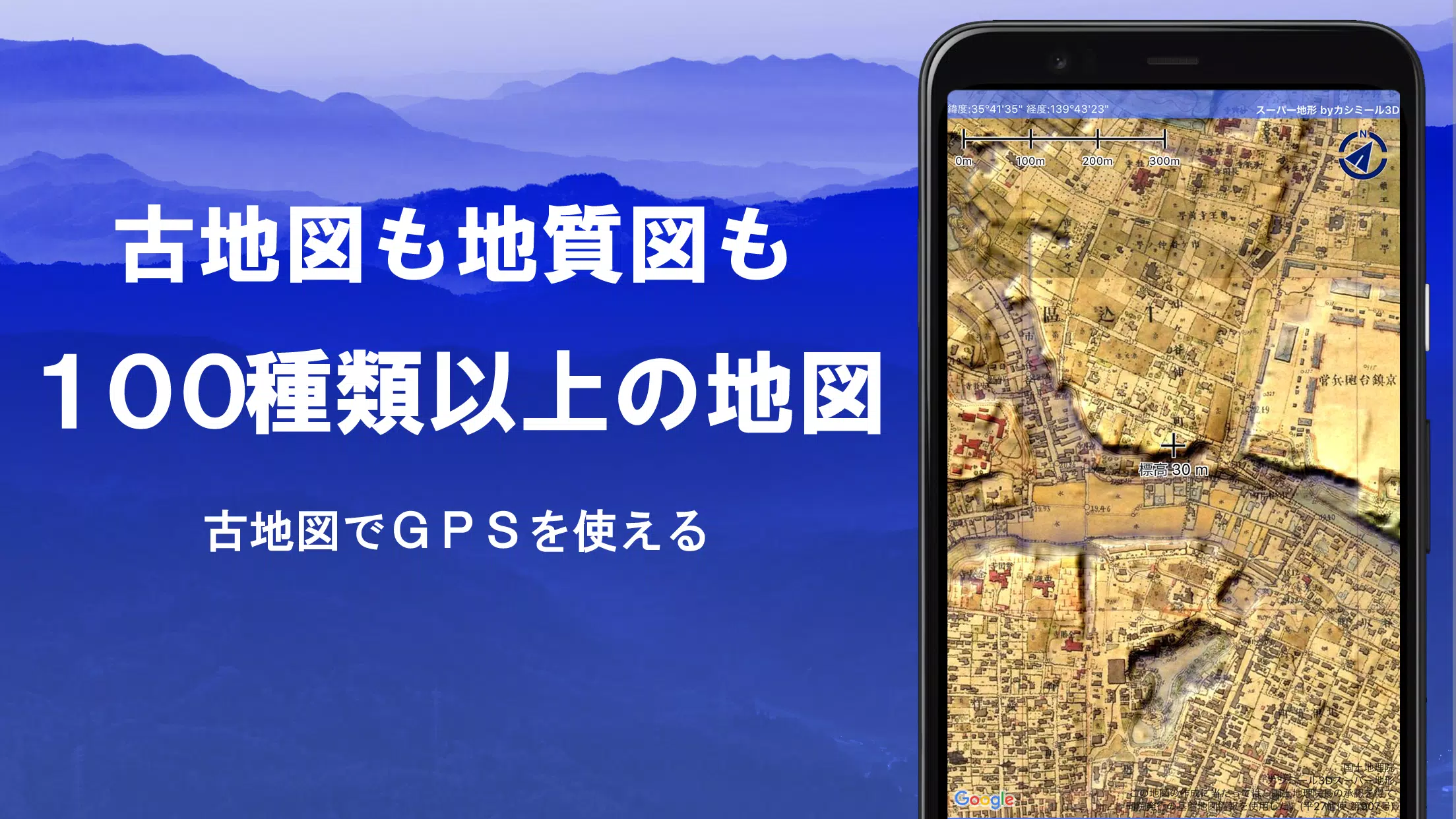
- Access a wide range of maps from the Geospatial Information Authority of Japan, including topographic, geological, historical, and prewar Ordnance Survey Department maps.
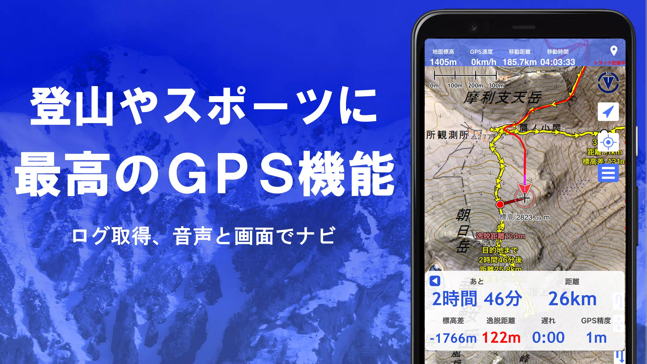
- Record your tracks (trajectories) with the GPS function, and enjoy GPX log input/output and editing capabilities.
- Benefit from features designed for urban walking, mountain climbing, and outdoor activities, such as GPS navigation with audio guidance, and data recording and editing.
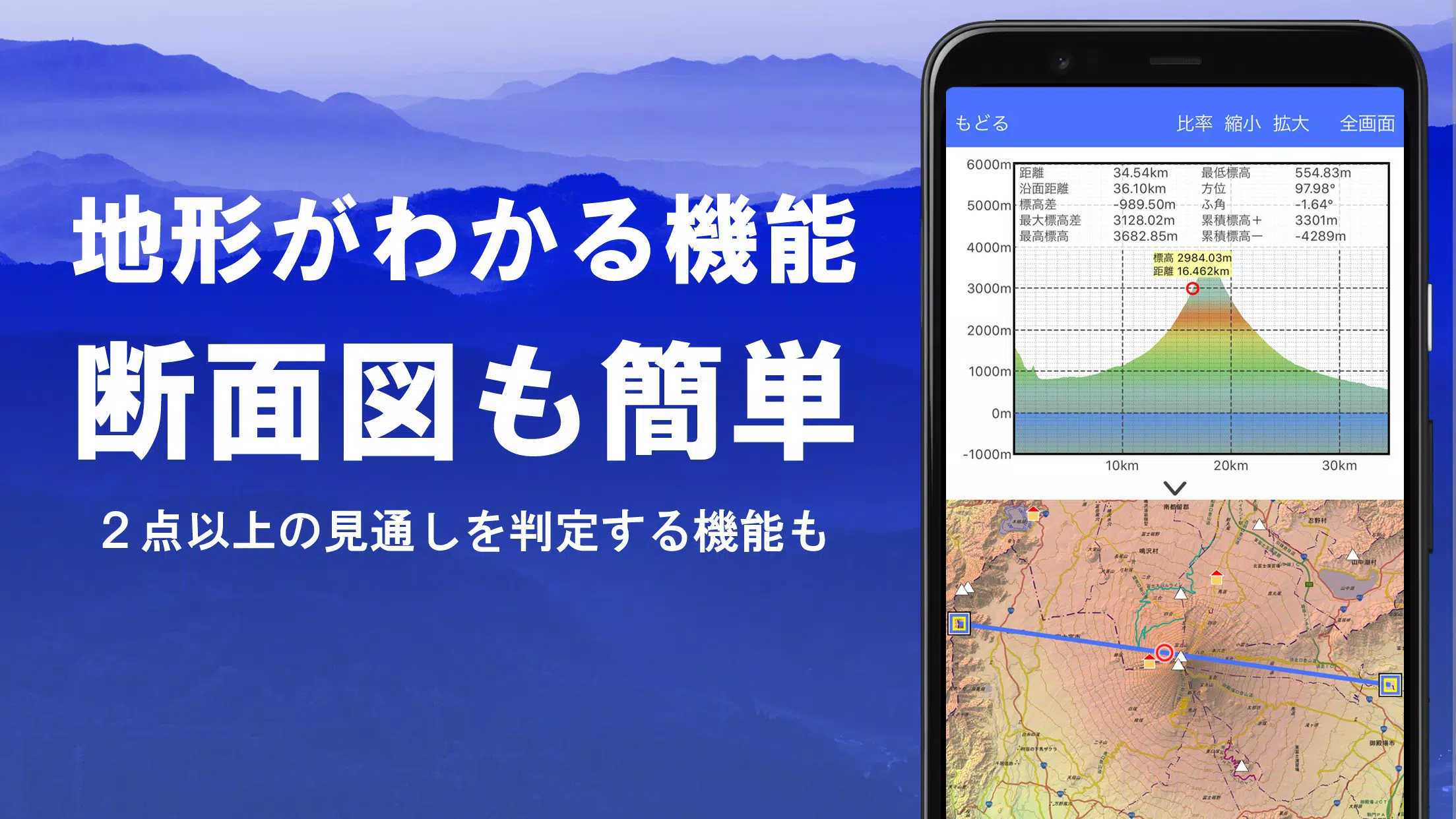
- Use the visibility determination function for creating cross-sectional diagrams, observation, and radio communication, with the option to display buildings.
- Experience the 360° panoramic view function, which includes mountain identification, sun and moon display, and GPS point visualization.
- Enjoy offline capabilities with GPS function, bulk map download, and map cache features, perfect for areas without radio signals.
- Associate photos with specific points on your journey.
- View contour lines generated from elevation data.
- Display the MGRS grid (UTM grid) for precise location tracking.
- Read, display, and edit GIS data from GeoJSON files.
- Draw shapes directly on the map.
- Use the app overseas for global adventures.
- Print maps or output them as PDFs for your records.
- Enjoy a dark theme for better visibility in low-light conditions.
A Wealth of Maps at Your Disposal
Super Terrain offers an extensive selection of over 100 map types, including our proprietary super topographic data and maps from the Geospatial Information Authority of Japan. Note that aerial photographs may not be available for all locations, with the "latest" and "around 1974" categories offering broader coverage. Maps using super terrain data are available for free for the first 5 days after app installation.
Creating Cross Sections and Outlooks
Easily draw cross sections through any point on the map with Super Terrain. The app also features a visibility judgment function, accounting for Earth's curvature and atmospheric differences, which is invaluable for route planning during climbs, assessing wireless visibility, and understanding terrain. Where PLATEAU building data is available, you can include buildings in your cross-sectional views.
Elevation Palette Function
Customize your map's appearance with the elevation palette function, allowing you to change the background color in 1cm increments to your preferred gradation.
Panoramic View
Explore panoramic observation maps to identify mountains from any location on the map. The 360° panorama integrates with your smartphone's compass, making it an essential tool for mountain identification. You can also view the sun and moon, including moon phases, to plan for phenomena like Diamond Fuji and Pearl Fuji. Additionally, display GPS points and create panoramic views of mountains worldwide.
GPS Function
Leverage your smartphone's GPS to obtain location information and record tracks with high-precision positioning suitable for serious mountain climbing and outdoor activities. Visualize your recorded tracks with parameters like elevation gain, speed, time, and elapsed time. The point alarm function alerts you with voice and sound when you approach designated points. Display photos linked to specific points and send the map center position to NaviCon.
GPS Track Summary Playback
Replay your track logs in full with the GPS track summary playback feature. It automatically matches and displays photos taken during your journey, with icons indicating photo locations that you can tap to view.
GPS Navigation Function
Navigate along preset tracks with the Track Navi function, which uses your smartphone's GPS. If you stray from the path, you'll be alerted by voice or sound, ensuring you stay on course during your climbs. Additionally, use route navigation for urban exploration and point navigation to reach specific locations.
GPS Data Editing Function
Manage GPS-related point, route, and track data with ease. Organize your data in folders displayed in a user-friendly tree format. Create tracks directly on the map and import/export data in GPX format from mountain climbing sites.
Map Usage Outside the Service Area (Offline)
Continue using maps even in areas without signal, such as during mountain climbs. The bulk download function allows you to download all scale maps for a specified area, ensuring you have the maps you need on-site. A cache function is also available for offline use.
Map History Function
The app remembers your viewed locations, allowing you to return to previous spots effortlessly.
Custom Map Compatibility
Import and use custom maps created with Kashmir 3D's map cutter. Display your own maps and scanned maps by dividing images into approximately 256 x 256 segments and sending the resulting kmz file to Super Terrain via email or Cloud Drive.
GeoJSON Compatibility
Display and edit points, linestrings, and polygons from GeoJSON format files, and draw new shapes on the map.
Print/PDF Output
Print any map area at a specified scale or create a PDF for your records.
Cooperation with Other Apps
Input and output GPS data in GPX, KML, and GDB formats, enabling data exchange with other apps, Kashmir 3D on your PC, and trajectory data from mountain climbing sites.
Backup Function
Back up all app data (excluding cached maps) and remove it from your smartphone. Restore your data even if you delete the app or experience a smartphone malfunction. An automatic backup feature using Google Drive ensures your data is always up-to-date. For detailed instructions, please refer to the manual.
About Billing Function
Some features, such as maps using super terrain data, GPS track functions, and cross-sectional views, require in-app purchases. After payment, the number of search results for place name searches increases.
- Fees: Annual payment of 780 yen/year.
- Free Trial: Enjoy a 5-day free trial after first installing the app. After 5 days, some features and maps will be unavailable unless you make a purchase. You will not be charged unless you initiate a purchase.
- Confirmation and Cancellation: Check or cancel automatic updates by opening Google Play, selecting "Regular Purchase" from the menu, and choosing "Super Terrain."
- Price Revision: Prices may change due to future feature enhancements. Early purchase is advantageous.
Terms of Use
The copyright holder and developer are not responsible for the outcomes of using this application. Upon first use of GPS, you will be prompted to allow location services. Continuous GPS use will drain your battery, so if your device is used for emergency communication, carry a spare battery. For an in-depth explanation of the navigation function, refer to the PDF at https://www.kashmir3d.com/online/superdemapp/superdem_navi.pdf. Note that some smartphones may interrupt or fail to record tracks due to power-saving features that close background apps. Turning off the screen while using Super Terrain may temporarily maintain recording, but this is not a permanent solution.
Screenshot
 Reviews
Post Comments+
Latest Apps
MORE+
Reviews
Post Comments+
Latest Apps
MORE+
-
 Auto Text: Automatic Message
Communication 丨 15.90M
 Download
-
 Speak & Translate All Language
Communication 丨 78.20M
Download
-
 Rakuten Viber Messenger
Communication 丨 99.20M
Download
-
 Clip TV for Android TV
Video Players & Editors 丨 21.10M
Download
-
 Lounge Prosperity Tiger
Productivity 丨 8.50M
Download
-
 CreationTV
Video Players & Editors 丨 12.90M
Download
Similar recommendations
MORE+
Top News
MORE+

-

-
 Shovel Knight Digs In, Promises More
Jun 25,2024
-

-
 Elden Ring Fan Shows Off Mohg Cosplay
Jan 22,2022
Topics
MORE+
- Your Guide to the Best News & Magazine Subscriptions
- Top Free Puzzle Games on Google Play
- Top Sports News and Score Apps
- Stylized Realistic Art Style Games for Android
- Fun Word Games to Play with Friends
- Top Action Games of 2024
- Must-Have Business Productivity Apps
- Relaxing Casual Games to Unwind With
Trending apps
MORE+
-
1

m.a.i.n59.72M
Introducing m.a.i.n, the revolutionary app that is changing the way we connect and share information. With m.a.i.n, you no longer need to carry around physical business cards or worry about sharing your contact details with strangers. Simply create a m.a.i.n Name and all your contact information and
-
2

Photos Recovery-Restore Images15.00M
PhotoRecovery: Restore Pics is a user-friendly Android app for effortlessly recovering deleted photos from internal and external storage without rooting. Its intuitive interface and robust features scan for and restore major image formats, letting you preview and selectively recover photos. An int
-
3

Yeahub-live video chat79.00M
YeaHub: Your Gateway to Seamless Video ChatStay connected with friends and loved ones, anytime, anywhere with YeaHub, the ultimate live video chat app. Experience crystal-clear video calls that bridge the distance, making communication more than just words. With YeaHub, you can engage in face-to-fac
-
4

Advanced Download Manager56.13M
Advanced Download Manager: Your Ultimate Download CompanionAdvanced Download Manager is the ultimate solution for anyone facing unreliable or slow internet connections. This powerful app acts as your indispensable download companion, ensuring seamless and uninterrupted downloads. Whether you're inte
-
5

YUMS57.16M
YUMS is the ultimate app designed to revolutionize your university experience. It combines convenience, organization, and timeliness to streamline every aspect of your academic life. Forget about the hassle of keeping track of class schedules and attendance manually. With YUMS, you can easily access
-
6

Blued TW151.19 MB
Requirements (Latest version)Android 6.0 or higher is required.
3.3 MB
Download194.2 MB
Download62.2 MB
Download108.1 MB
Download55.7 MB
Download5.4 MB
Download