


 Download
  Application Description
Turn your phone into a robust off-road GPS using offline topographic maps!
No advertisements ~ No data sharing & monetization ~ No analytics ~ No third-party libraries
AlpineQuest is the ultimate solution for all outdoor activities and sports, including hiking, running, trailing, hunting, sailing, geocaching, off-road navigation, and much more.
You can access and store locally a wide range of online topographic maps, which remain available even when you're out of cell coverage. AlpineQuest also supports numerous on-board file-based raster map formats.
By utilizing the GPS and the magnetic sensor of your device (with a compass display), getting lost becomes a thing of the past: you are localized in real-time on the map, which can also be oriented to align with your current view.
Save and retrieve an unlimited number of placemarks, share them with your friends. Track your path, obtain advanced statistics, and view interactive graphics. You'll never question what you can achieve again.
By staying fully operational out of cell coverage (common in mountainous areas or abroad), AlpineQuest assists you in all your deep wilderness exploration desires…
Don’t hesitate, try this Lite version for free right now!
PLEASE report suggestions and issues on our dedicated forum at https://www.alpinequest.net/forum (no registration required, all questions answered) and not in the comments section.
Key features include (for the full version):
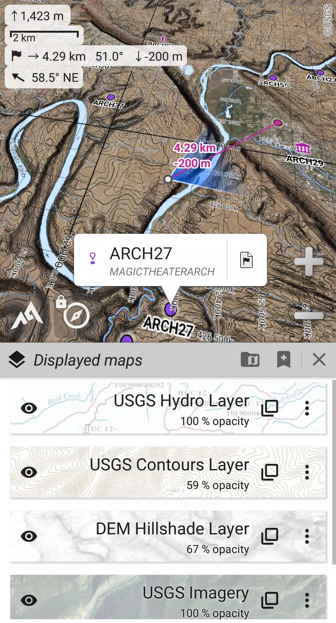
★★ Maps ★★
• Built-in online maps (with automatic local storage; road, topo, and satellite maps included) and online layers (road names, hillshade, contours);
• Easily access more online maps and layers with one click from the included community maps list (covering all major worldwide maps and many local topo maps);
• Complete area storage of online maps for offline use;
• On-board offline maps support (raster) including KMZ Overlays, OziExplorer OZFx2, OZFx3 (partly) and calibrated images, GeoTiff, GeoPackage GeoPkg, MbTile, SqliteDB, and TMS zipped tiles (visit our website to get MOBAC, the free map creator);
• QuickChart Memory Map support (.qct maps only, .qc3 maps not compatible);
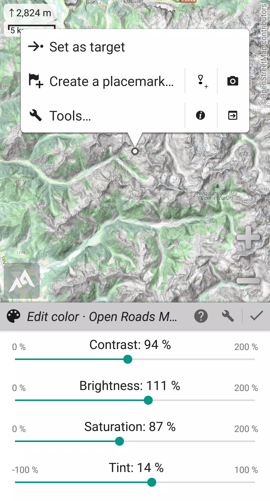
• Built-in image calibration tool to use any scan or picture as a map;
• Digital elevation model on-board storage (1-arcsec SRTM DEM) and support for HGT elevation files (both 1-arcsec and 3-arcsec resolutions) allowing display of terrain, hillshade, and steep slopes;
• Polar maps (Arctic and Antarctic) support;
• Display multiple maps in layers, with per-map opacity/contrast/color/tint/blending control.
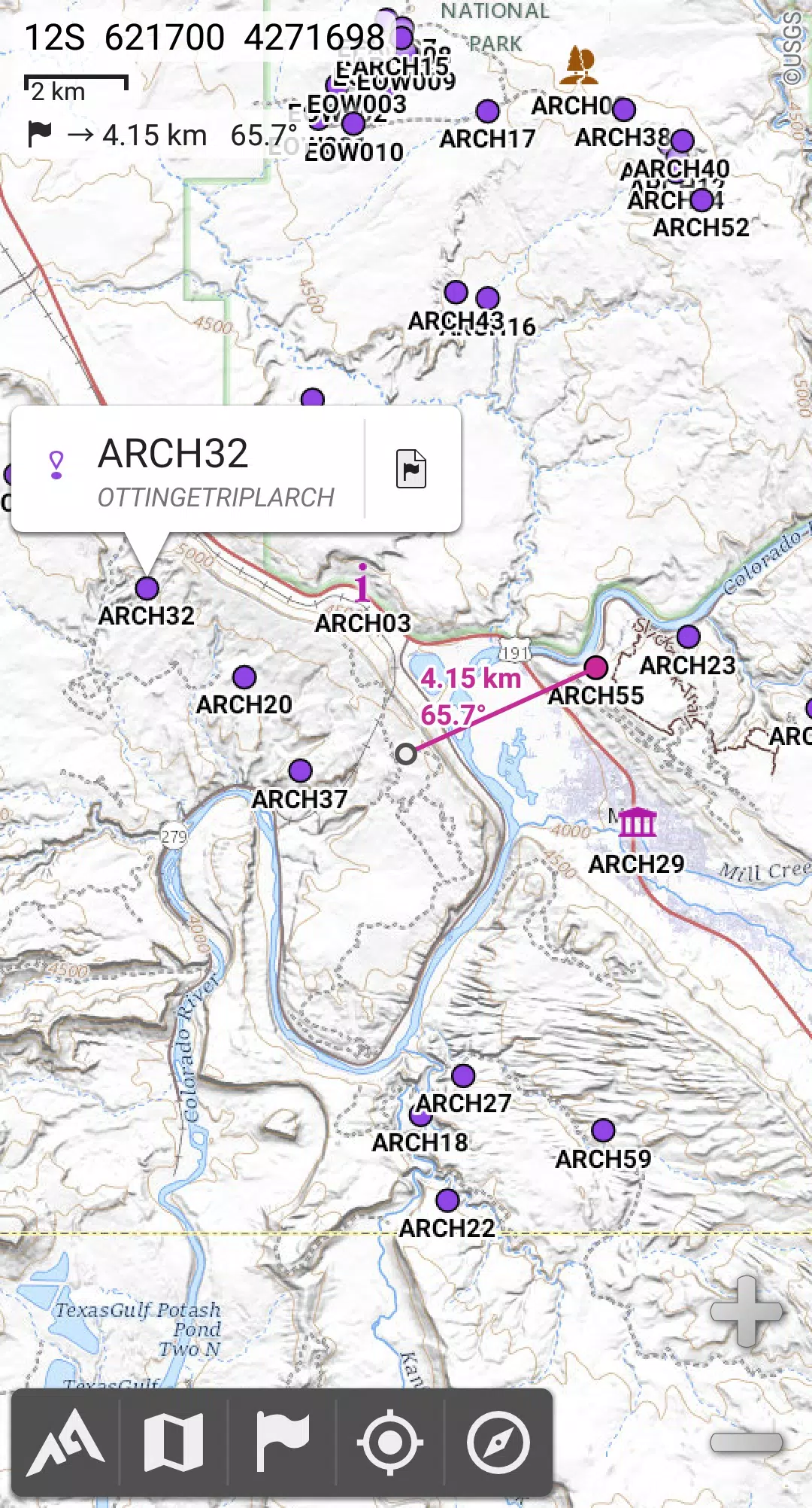
★★ Placemarks ★★
• Create, display, save, and restore an unlimited number of items (waypoints, routes, areas, and tracks);
• Import/export GPX files, Google Earth KML/KMZ files, and CSV/TSV files;
• Import ShapeFile SHP/PRJ/DBF, OziExplorer WPT/PLT, GeoJSON, IGC tracks, Geocaching LOC waypoints and export AutoCAD DXF files;
• Save and share online locations with other users using Community Placemarks;
• Access details, advanced statistics, and interactive graphics on various items;
• Use the Time Controller to replay time-tagged tracks.
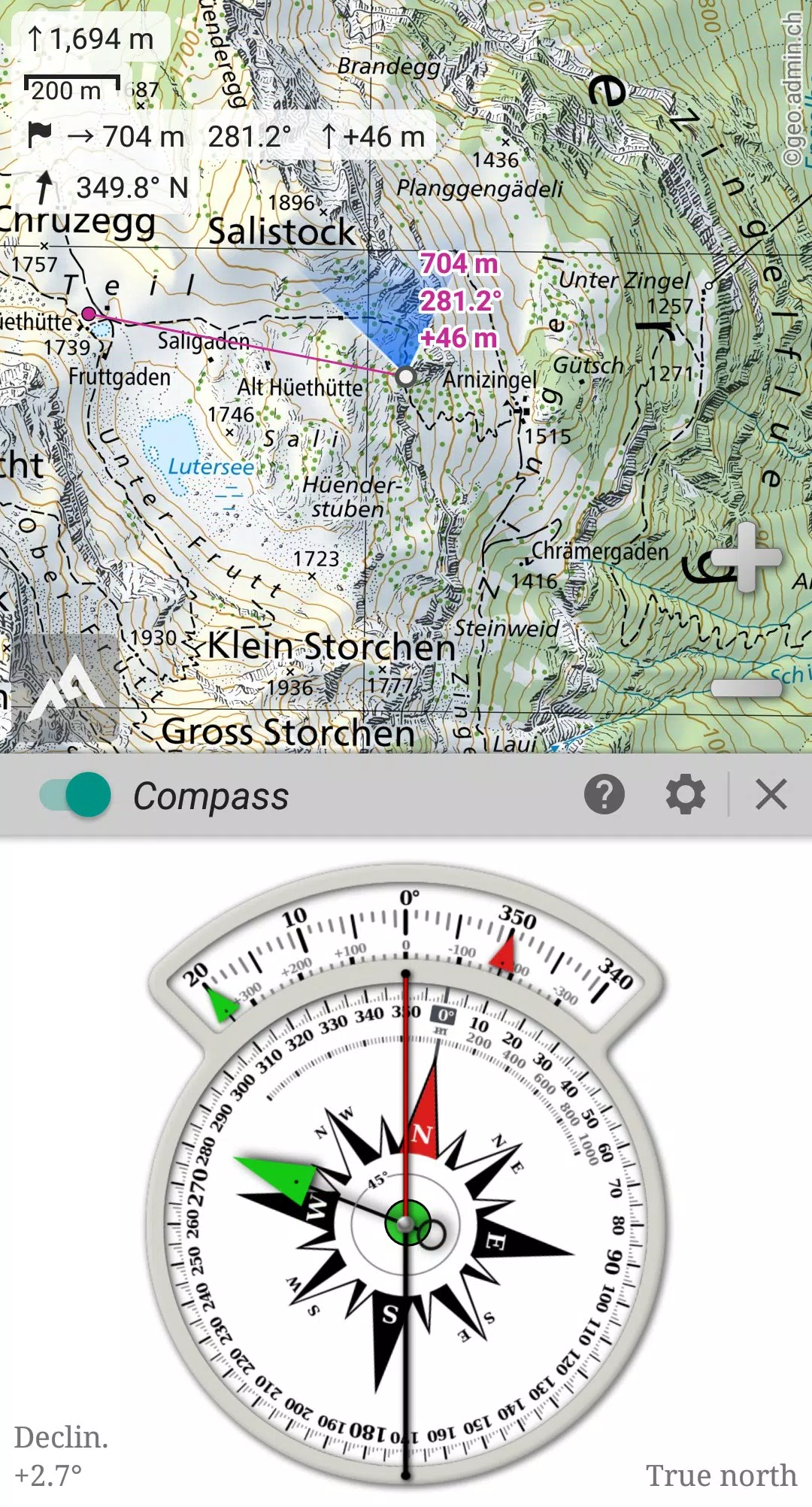
★★ GNSS Position / Orientation ★★
• On-map geolocation using device GNSS receivers (GPS/Glonass/Galileo/…) or Network;
• Map orientation, compass, and target finder;
• Built-in GNSS/Barometric track recorder (capable of long tracking, running in a separate and light process) with battery level and network strength recording;
• Proximity alerts and leave path alerts;
• Barometer support (on compatible devices).
★★ And more ★★
• Metric, imperial, nautical, and hybrid distance units;
• Latitude/Longitude and grid coordinate formats (WGS, UTM, MGRS, USNG, OSGB, SK42, Lambert, QTH, …) with on-map grids display;
• Ability to import hundreds of coordinate formats from https://www.spatialreference.org;
• …
What's New in the Latest Version 2.3.8d
Last updated on Aug 14, 2024
2.3.8b/c/d
• Added a new setting to customize the display style and side of the menu bar;
• Enhanced support for recent Android versions;
• Improved backup and restore tool;
• Updated default URL when sharing coordinates as text;
• Added the ability to set the application “Media” folder as default for placemarks, icons, pictures, and file-based maps;
• Included Croatian and Persian translations;
• Various improvements and bug fixes.
Screenshot
 Reviews
Post Comments+
Latest Apps
MORE+
Reviews
Post Comments+
Latest Apps
MORE+
-
 CricScore Line Guru Pro - Live
Personalization 丨 34.30M
 Download
-
 Vip Betting Tips
Personalization 丨 17.20M
Download
-
 Mobby
Mobby
Personalization 丨 50.50M
Download
-
 WEATHER NOW Mod
Lifestyle 丨 58.30M
Download
-
 Speak - Language Learning
Lifestyle 丨 195.80M
Download
-
 Pixly – Icon Pack Mod
Lifestyle 丨 121.70M
Download
Similar recommendations
MORE+
Top News
MORE+

-

-
 Shovel Knight Digs In, Promises More
Jun 25,2024
-

-
 Elden Ring Fan Shows Off Mohg Cosplay
Jan 22,2022
Topics
MORE+
- Your Guide to the Best News & Magazine Subscriptions
- Top Free Puzzle Games on Google Play
- Top Sports News and Score Apps
- Stylized Realistic Art Style Games for Android
- Fun Word Games to Play with Friends
- Top Action Games of 2024
- Must-Have Business Productivity Apps
- Relaxing Casual Games to Unwind With
Trending apps
MORE+
-
1

m.a.i.n59.72M
Introducing m.a.i.n, the revolutionary app that is changing the way we connect and share information. With m.a.i.n, you no longer need to carry around physical business cards or worry about sharing your contact details with strangers. Simply create a m.a.i.n Name and all your contact information and
-
2

Photos Recovery-Restore Images15.00M
PhotoRecovery: Restore Pics is a user-friendly Android app for effortlessly recovering deleted photos from internal and external storage without rooting. Its intuitive interface and robust features scan for and restore major image formats, letting you preview and selectively recover photos. An int
-
3

Yeahub-live video chat79.00M
YeaHub: Your Gateway to Seamless Video ChatStay connected with friends and loved ones, anytime, anywhere with YeaHub, the ultimate live video chat app. Experience crystal-clear video calls that bridge the distance, making communication more than just words. With YeaHub, you can engage in face-to-fac
-
4

Blued TW151.19 MB
Requirements (Latest version)Android 6.0 or higher is required.
-
5

Advanced Download Manager56.13M
Advanced Download Manager: Your Ultimate Download CompanionAdvanced Download Manager is the ultimate solution for anyone facing unreliable or slow internet connections. This powerful app acts as your indispensable download companion, ensuring seamless and uninterrupted downloads. Whether you're inte
-
6

local.ch: booking platform3.55M
local.ch: booking platform, the ultimate app for all your business and service needs in Switzerland and Liechtenstein. With over 500,000 businesses listed, you can easily find contact details and book tables or appointments online hassle-free. Looking for a restaurant with available tables on a spe
3.55M
Download36.00M
Download10.31M
Download27.19M
Download64.30M
Download57.00M
Download