
All-In-One Offline Maps
Category:Maps & Navigation Developer:Psyberia
Size:7.2 MBRate:4.5
OS:Android 2.1+Updated:May 10,2025

 Download
  Application Description
OfflineMaps provides you with access to an extensive selection of maps, ensuring you never lose your way, no matter where you are.
No advertisements ~ No data sharing & monetization ~ No analytics ~ No third party libraries
Tired of waiting for maps to load? With All-In-One OfflineMaps, once a map is displayed, it's stored on your device for quick access, even without an internet connection.
• Looking for more than just roads on your maps? You'll find everything you need here;
• Frequently visit areas with poor network coverage? No problem—everything remains accessible;
• Traveling abroad? You'll never feel lost again;
• Concerned about data limits? This app will help you conserve your data usage.
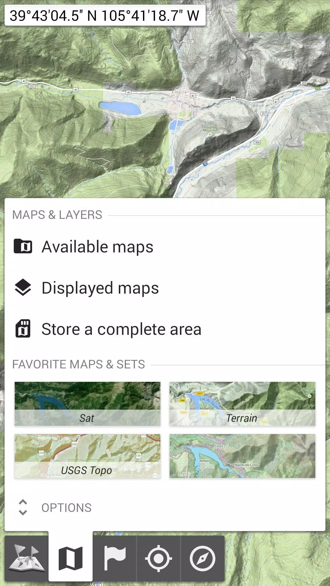
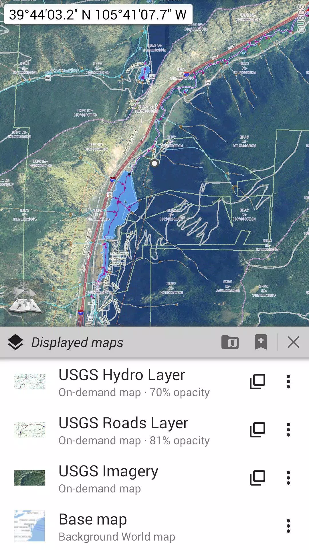
★★ Maps ★★
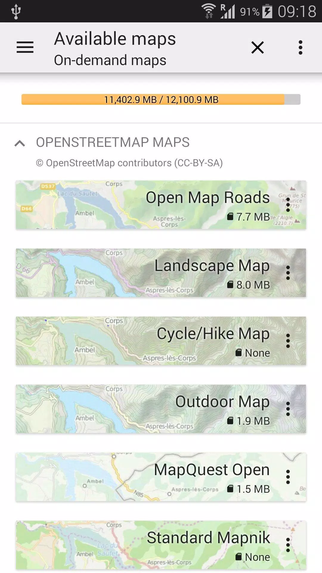
A wide variety of maps are at your fingertips, including traditional road maps, topographic maps, aerial (satellite) imagery, and various overlays that can be added to any map: OpenStreetMap (Roads, Topo), USGS National Map (High-resolution topo, Aerial imagery), Worldwide Military Soviet topographic maps, and more.
• Maps can be layered with precise control over opacity;
• Easily select and save large areas with just a few clicks;
• Stored maps can be clearly viewed and effortlessly deleted when no longer needed.
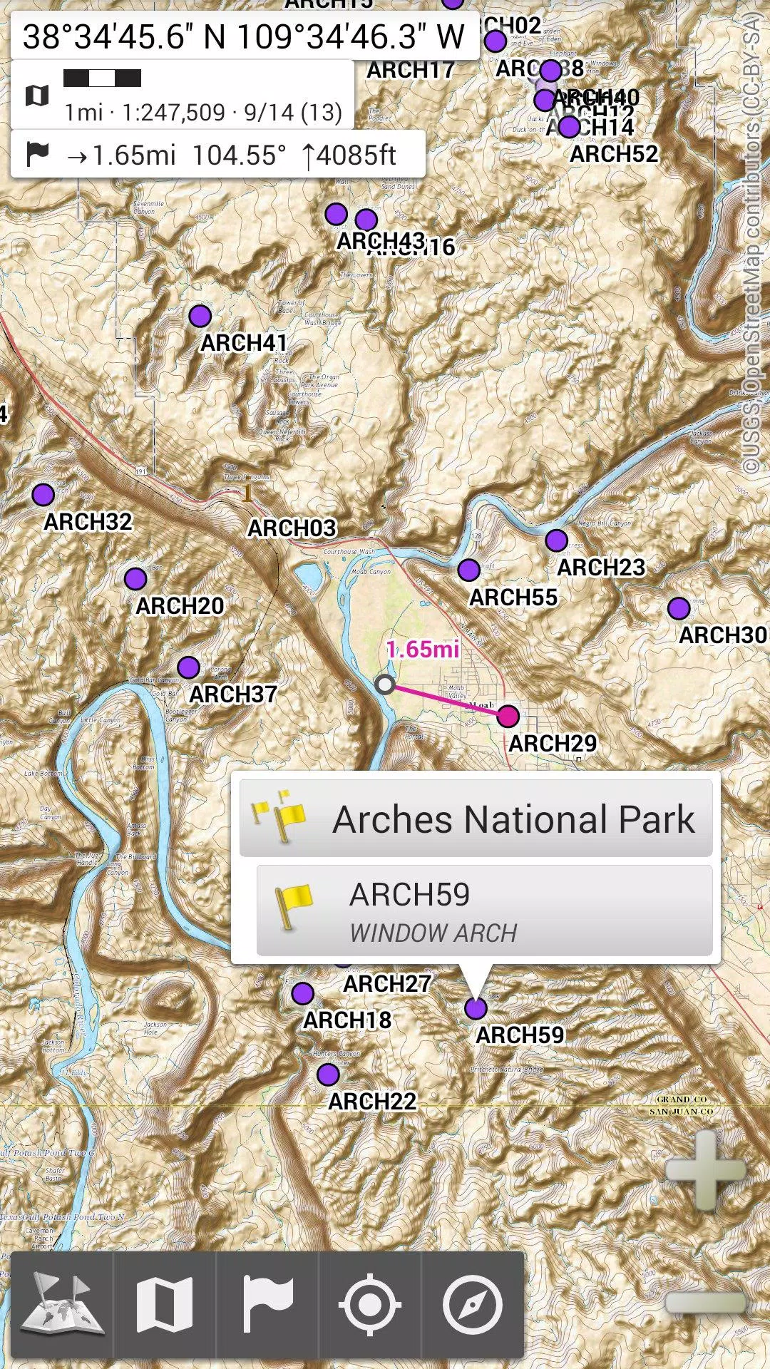
★★ Display, Store, and Retrieve Unlimited Placemarks ★★
Add various elements to your maps, such as waypoints, icons, routes, areas, and tracks.
Effortlessly manage these items using the robust SD-Card Placemarks Explorer.
★★ On-Map GPS Location & Orientation ★★
Your actual location and direction are clearly shown on the map, which can be rotated to align with your real-world orientation (device-dependent).
Toggle on/off easily to conserve battery life.
Additional Features:
• Choose from metric, imperial, or hybrid distance units;
• Support for GPS Latitude/Longitude and multiple grid coordinate systems (UTM, MGRS, USNG, OSGB Grid, Irish Grid, Swiss Grid, Lambert Grids, DFCI Grid, QTH Maidenhead Locator System, and more);
• Ability to import numerous coordinate formats from https://www.spatialreference.org;
• Display of on-map grids;
• Full-screen map view;
• Multi-touch zoom;
• And much more!
★★ Need More? ★★
If you're an avid adventurer, consider AlpineQuest Off-Road Explorer, the comprehensive outdoor solution built on All-In-One OfflineMaps, featuring a powerful GPS Track Recorder and additional tools: https://www.alpinequest.net/google-play
Screenshot
 Reviews
Post Comments+
Latest Apps
MORE+
Reviews
Post Comments+
Latest Apps
MORE+
-
 Auto Text: Automatic Message
Communication 丨 15.90M
 Download
-
 Speak & Translate All Language
Communication 丨 78.20M
Download
-
 Rakuten Viber Messenger
Communication 丨 99.20M
Download
-
 Clip TV for Android TV
Video Players & Editors 丨 21.10M
Download
-
 Lounge Prosperity Tiger
Productivity 丨 8.50M
Download
-
 CreationTV
Video Players & Editors 丨 12.90M
Download
Similar recommendations
MORE+
Top News
MORE+

-

-
 Shovel Knight Digs In, Promises More
Jun 25,2024
-

-
 Elden Ring Fan Shows Off Mohg Cosplay
Jan 22,2022
Topics
MORE+
- Your Guide to the Best News & Magazine Subscriptions
- Top Free Puzzle Games on Google Play
- Top Sports News and Score Apps
- Stylized Realistic Art Style Games for Android
- Fun Word Games to Play with Friends
- Top Action Games of 2024
- Must-Have Business Productivity Apps
- Relaxing Casual Games to Unwind With
Trending apps
MORE+
-
1

m.a.i.n59.72M
Introducing m.a.i.n, the revolutionary app that is changing the way we connect and share information. With m.a.i.n, you no longer need to carry around physical business cards or worry about sharing your contact details with strangers. Simply create a m.a.i.n Name and all your contact information and
-
2

Photos Recovery-Restore Images15.00M
PhotoRecovery: Restore Pics is a user-friendly Android app for effortlessly recovering deleted photos from internal and external storage without rooting. Its intuitive interface and robust features scan for and restore major image formats, letting you preview and selectively recover photos. An int
-
3

Yeahub-live video chat79.00M
YeaHub: Your Gateway to Seamless Video ChatStay connected with friends and loved ones, anytime, anywhere with YeaHub, the ultimate live video chat app. Experience crystal-clear video calls that bridge the distance, making communication more than just words. With YeaHub, you can engage in face-to-fac
-
4

Advanced Download Manager56.13M
Advanced Download Manager: Your Ultimate Download CompanionAdvanced Download Manager is the ultimate solution for anyone facing unreliable or slow internet connections. This powerful app acts as your indispensable download companion, ensuring seamless and uninterrupted downloads. Whether you're inte
-
5

YUMS57.16M
YUMS is the ultimate app designed to revolutionize your university experience. It combines convenience, organization, and timeliness to streamline every aspect of your academic life. Forget about the hassle of keeping track of class schedules and attendance manually. With YUMS, you can easily access
-
6

Blued TW151.19 MB
Requirements (Latest version)Android 6.0 or higher is required.
3.3 MB
Download194.2 MB
Download62.2 MB
Download108.1 MB
Download55.7 MB
Download5.4 MB
Download