


 Download
  Application Description
Navigate with confidence using 2GIS, a comprehensive offline map and GPS navigation system designed for both car drivers and pedestrians. With features like live traffic updates, parking information, and transit routes, 2GIS ensures you're never lost, whether online or offline.
Feel at home in any city with 2GIS's detailed maps and navigation:
- Easily find addresses, businesses, phone numbers, operating hours, and available goods or services.
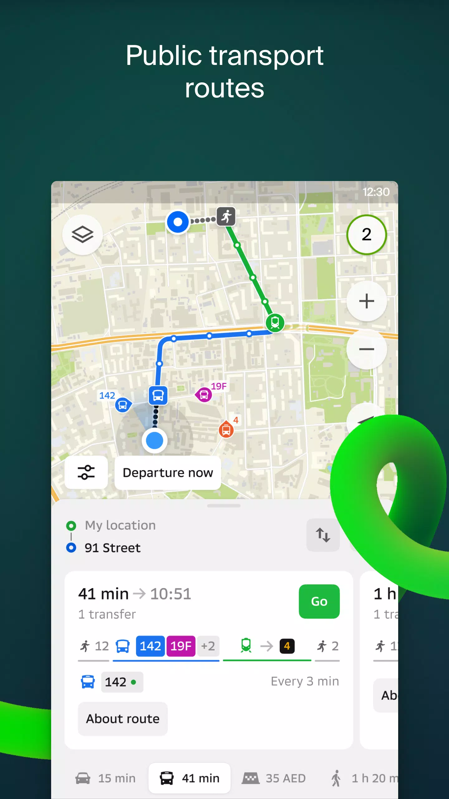
- Plan your journey by car, bus, subway, or follow pedestrian navigation routes.
- Locate building entrances and nearby parking facilities with ease.
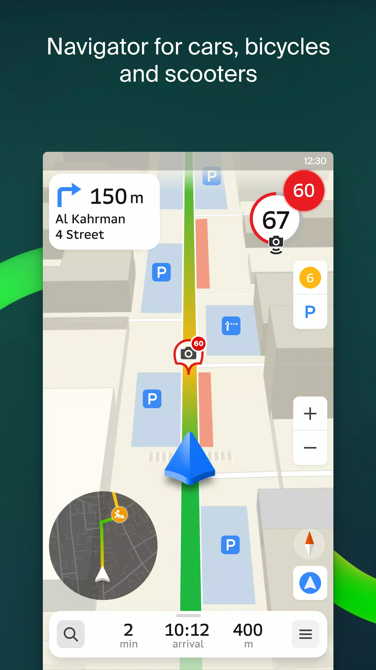
Our accurate maps pinpoint districts, buildings, streets, bus stops, subway stations, gas stations, sports facilities, and more. The GPS navigation system takes into account real-time traffic conditions, road signs, speed cameras, toll roads, and unpaved routes, offering directions between cities and multiple stops. It's also compatible with Android Auto.
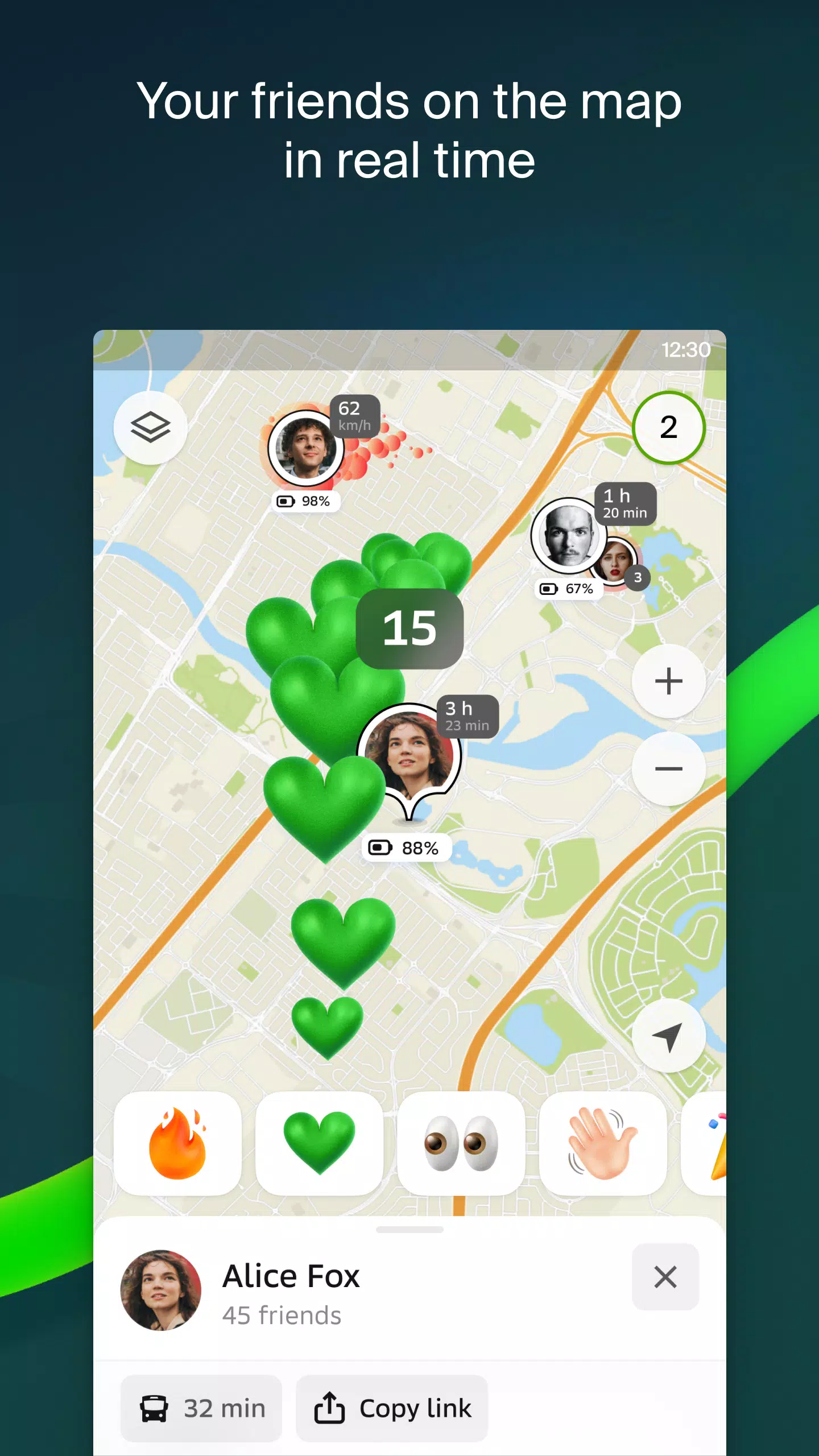
Stay connected with loved ones using the live friends' location feature, allowing you to track the GPS location of your kids or friends for safety. Share fun stickers and monitor battery levels, with full control over who can see your location.
Stay informed with real-time road event reports, including accidents, blocked streets, and speed camera locations, all displayed directly on the map. 2GIS also provides public transport schedules and online routes, ensuring you're always on time.
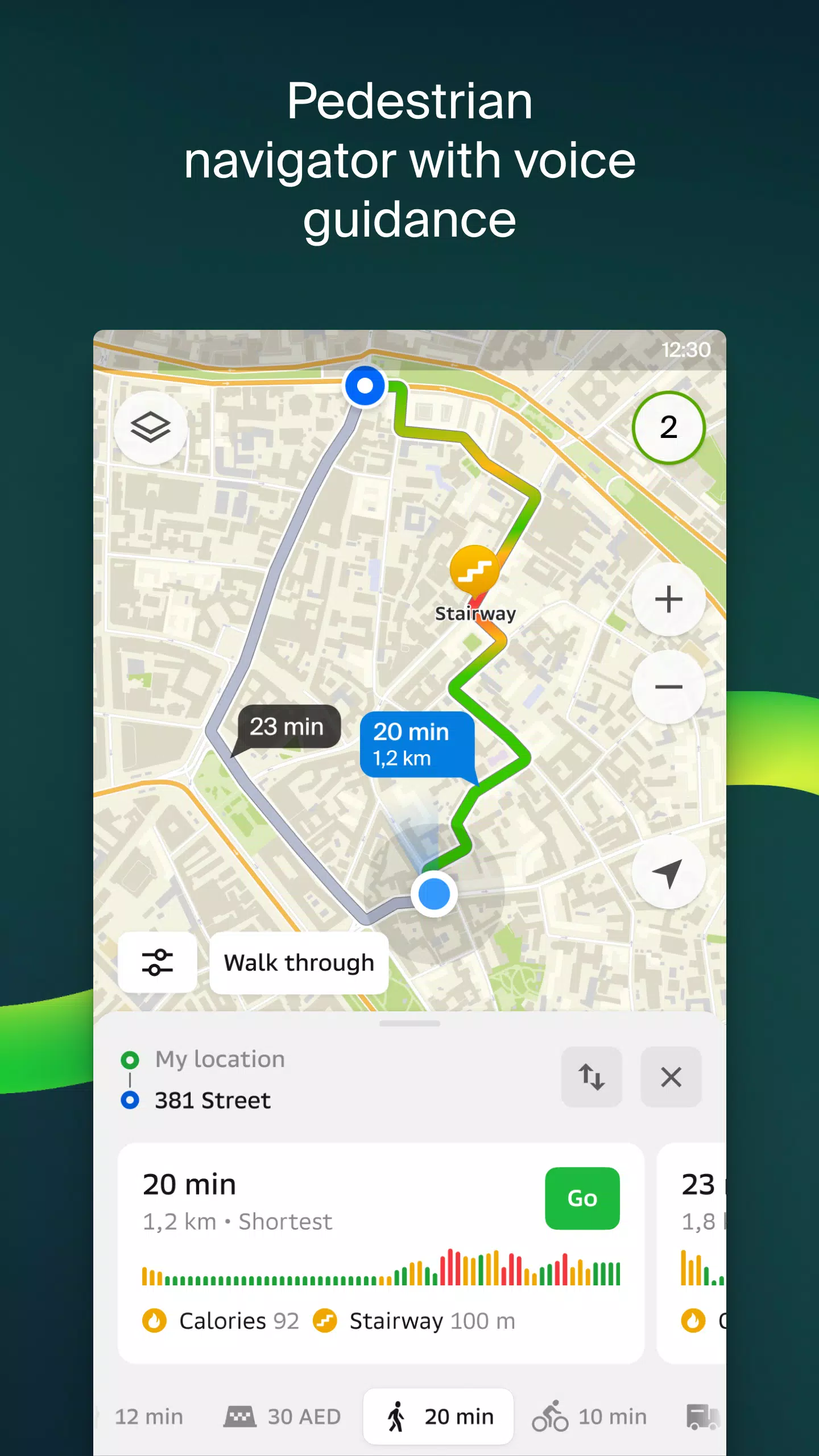
For those on foot, our pedestrian navigation system offers walking routes with background operation and voice guidance. Truck drivers can benefit from specialized navigation that considers vehicle and cargo specifics.
Explore with ease using our detailed directory, which includes addresses, entrances, postal codes, phone numbers, operating hours, social media links, and websites. Users can contribute photos and reviews to enhance the directory.
Discover the highlights of your destination with our travel guide, featuring main attractions and Wi-Fi hotspots. For smartwatch users, the 2GIS Notifications companion app on Wear OS 3.0 or later versions offers hands-free navigation with vibration alerts for turns and bus stops.
Available maps cover cities in the UAE, Russia, Belarus, Kazakhstan, Uzbekistan, Azerbaijan, and Kyrgyzstan, including Dubai, Moscow, Minsk, Almaty, and many more.
For support, reach out to us at [email protected].
Screenshot
 Reviews
Post Comments+
Latest Apps
MORE+
Reviews
Post Comments+
Latest Apps
MORE+
-
 Rakuten Viber Messenger
Communication 丨 99.20M
 Download
-
 Clip TV for Android TV
Video Players & Editors 丨 21.10M
Download
-
 Lounge Prosperity Tiger
Productivity 丨 8.50M
Download
-
 CreationTV
Video Players & Editors 丨 12.90M
Download
-
 EBCNews
News & Magazines 丨 12.03M
Download
-
 Hubit
Hubit
News & Magazines 丨 22.10M
Download
Similar recommendations
MORE+
Top News
MORE+

-

-
 Shovel Knight Digs In, Promises More
Jun 25,2024
-

-
 Elden Ring Fan Shows Off Mohg Cosplay
Jan 22,2022
Topics
MORE+
- Your Guide to the Best News & Magazine Subscriptions
- Top Free Puzzle Games on Google Play
- Top Sports News and Score Apps
- Stylized Realistic Art Style Games for Android
- Fun Word Games to Play with Friends
- Top Action Games of 2024
- Must-Have Business Productivity Apps
- Relaxing Casual Games to Unwind With
Trending apps
MORE+
-
1

m.a.i.n59.72M
Introducing m.a.i.n, the revolutionary app that is changing the way we connect and share information. With m.a.i.n, you no longer need to carry around physical business cards or worry about sharing your contact details with strangers. Simply create a m.a.i.n Name and all your contact information and
-
2

Photos Recovery-Restore Images15.00M
PhotoRecovery: Restore Pics is a user-friendly Android app for effortlessly recovering deleted photos from internal and external storage without rooting. Its intuitive interface and robust features scan for and restore major image formats, letting you preview and selectively recover photos. An int
-
3

Yeahub-live video chat79.00M
YeaHub: Your Gateway to Seamless Video ChatStay connected with friends and loved ones, anytime, anywhere with YeaHub, the ultimate live video chat app. Experience crystal-clear video calls that bridge the distance, making communication more than just words. With YeaHub, you can engage in face-to-fac
-
4

Advanced Download Manager56.13M
Advanced Download Manager: Your Ultimate Download CompanionAdvanced Download Manager is the ultimate solution for anyone facing unreliable or slow internet connections. This powerful app acts as your indispensable download companion, ensuring seamless and uninterrupted downloads. Whether you're inte
-
5

YUMS57.16M
YUMS is the ultimate app designed to revolutionize your university experience. It combines convenience, organization, and timeliness to streamline every aspect of your academic life. Forget about the hassle of keeping track of class schedules and attendance manually. With YUMS, you can easily access
-
6

Blued TW151.19 MB
Requirements (Latest version)Android 6.0 or higher is required.
3.3 MB
Download194.2 MB
Download62.2 MB
Download108.1 MB
Download55.7 MB
Download5.4 MB
Download